![]()
![]()
![]()
![]()
![]()
![]()
![]()
![]()
![]()
![]()
![]()
![]()
![]()
![]()
![]()
![]()
![]()
![]()
![]()
![]()
![]()
![]()
![]()
![]()
![]()
![]()
![]()
![]()
![]()
 We
invite you to take a virtual tour of some
of our most popular travel destinations including the
historic mountain communities of Keene, Keene Valley, Lake Placid, Jay, Wilmington,
Saranac Lake, Blue Mountain Lake, and Tahawus.
We
invite you to take a virtual tour of some
of our most popular travel destinations including the
historic mountain communities of Keene, Keene Valley, Lake Placid, Jay, Wilmington,
Saranac Lake, Blue Mountain Lake, and Tahawus.
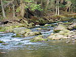
Keene
and Keene Valley 'Home of the High Peaks'
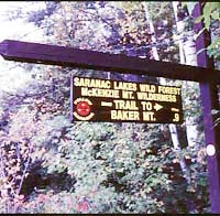
The greatest number of high peaks in the Adirondacks (in a single location) rise majestically in the Keene/Keene Valley Region making this area a meca for hikers, climbers and other visitors who wish to experience the remarkable beauty of the Adirondack mountains. There are literally hundreds of trail heads located in the tiny hamlet of Keene including the trail to the summit of Mt. Marcy, the highest mountain in New York State. Every year the Annual Adirondack Mountaineering Festival is held mid January in Keene Valley. The event is a celebration of mountaineering that includes a variety of ice climbing and mountaineering clinics.
The 46 High Peaks
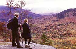 |
| Airondack
Hikers Photo courtesy of Jim Grant |
The
High Peaks Region is famous for its magnificant 46 peaks including Mt. Marcy,
the highest peak in New york State, with an elevation of 5344' .The 46 peaks include
the following mountains (listed in order of height):
Mt. Marcy, Algonquin Peak, Mt. Haystack, Mt. Skylight, Whiteface Mtn,Dix Mtn.
, Gray Peak, Iroquois Peak , Basin Mtn., Gothics, Mt. Colden, Giant Mtn., Nippletop,
Santanoni Peak, Mt. Redfield, Wright Peak, Saddleback Mtn., Panther Peak, Tabletop
Mtn., Rocky Peak Ridge, Macomb Mtn., Armstrong Mtn. ,Hough Peak, Seward Mtn.,
Mt. Marshall, Allen Mtn., Big Slide Mtn., Esther Mtn. , Upper Wolfjaw, Lower Wolfjaw
, Street Mtn., Phelps Mtn., Mt. Donaldson, Seymour Mtn., Sawteeth, Cascade Mtn.,
South Dix, Porter Mtn., Mt. Colvin, Mt. Emmons, Dial Mtn., East Dix, Blake, Cliff
Mtn., Nye Mtn., and Couchsachraga Peak.
Select
Adirondack Hikes and Trail Descriptions
The
Algonquin tour
An introduction the many landscapes of mountains, brooks
and lakes of the Adirondack. The best way to discover the second highest summit
of the Adirondack with a trip to some remote areas. The whole hike is a loop of
19 km. This may look very long but its all downhill after the summit of Algonquin.
All the beautiful nature scenes make this one a must to do for a hiker with an
average experience.
Mount Marcy:
This
is the highest mountain in the Adirondack with 5344 feet. Marcy is located in
the middle of the High Peaks Region. This mountain must be seen from a very close
location to be able to admire its beauty. Three of the major accesses to the Adirondack
region make possible a day hike to it. The shortest approach start at Heart Lake
and follows in and out the Van Hoevenberg Trail. This is a 23,75 km hike that
takes an average of 7˝ hours. The easiest way to shorten this distance is to camp
at Marcy Dam. This will cut 7,3 km to the distance. Marcy Dam is a rustic camping
area. It takes an hour of walk to get there from Heart Lake.
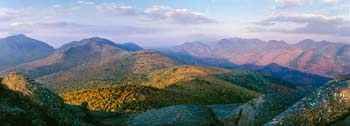 |
| "View
from Noonmark" |
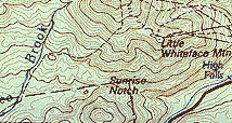
Gothics
Gothics, the 10th highest peak, has an
impressive 360° view. This proposed hike is less popular than the one starting
from The Garden, but it has a lot of things to see as: many viewpoints of the
Gothics Arch, an impressive ascent to the Pyramid summit on your way down and
a passage near two of the highest waterfalls in the Adirondack. The whole hike
is a loop of 21 km. The only drawback is the long and doll Lake Road you will
walk on your way in and out.
Colden
Colden is located between Marcy and Algonquin. It offers a 360° summit view
and a long open ridge. This trip is an other way to visit the great area of Avalanche
Pass. The whole hike is a loop of 21 km.
Phelps
A small summit from the list of those over 4,000 feet but its half open summit
has one of the best views in the Adirondack. Over 10 km of the trail is on flat
or low grade ground. The whole hike is 14 km long.
Noonmark
An open summit that is just under the 4,000 feet level, very similar to Cascade.
It has a better viewpoint toward many of the highest peaks than Cascade. If you're
looking for a longer trail, it's possible to make a loop and even add Round Mountain
on your way. The shortest hike has a total of 6.6 km.
Adirondack Trail Guide
and Hiking
Resource Center


Hiking in Other Regions | |
 | |
![]()
"Donate that old
car or pickup to your favorite charity & receive a valuable tax deduction...All
with just one click!"
| Donate
Your Used Vehicle to Charity! |
| Donate
your used car, boat, motorcycle, van or RV to your favorite charity & receive
full fair market value as a tax deduction! Click here to learn more and search for your favorite charity! Free nationwide pickup and no complicated paperwork. It's fast and easy. All vehicles accepted. |
Search and choose from hundreds of religious institutions, schools, and charitable organizations including cancer research, multiple sclerosis and heart disease.
Dining | Summer Sports | Winter Sports | Arts & Crafts | Attractions
Shopping | Adirondack Kids | Adirondack Lifestyles | Education
Business Profiles | Community Links | Business Directory | Classifieds
Adirondack History | Bulletin Board | Chat Room | Guestbook Comments | Return Home
![]()
New
York State & Vermont
Travel Guide Network
We
invite you to visit one of the largest and most comprehensive award winning travel
networks in New York State
& neighboring Vermont .
Choose your visitor
guide by clicking on any one of the links below!
Adirondacks.com
| AdirondackRealEstate.com |
AdirondackRentals.com |GlensFalls.com
| LakePlacidNY.com | SaranacLakeNewYork.com
| Saratoga-NewYork.com | Upstate-NewYork.com
| LakeChamplainValley.com | Burlington-Vermont.com
| ThousandIslandsNewYork.com |
MaloneNY.com | NorthCreekNY.com
| WestportNewYork.com | CliftonParkNewYork.com
|
Albany-New-York.com
| Troy-NewYork.com | Utica-NewYork.com
| Rome-NewYork.com | WarrensburgNewYork.com
| Potsdam-NewYork.com | AdirondackHighPeaks.com
| Canton-NewYork.com
| Massena-NewYork.com | Plattsburgh-NewYork.com
| LakePlacid-NewYork.com | GlensFalls.net
| SchroonLakeNewYork.com | KeeneNY.com
| KeeneValleyNY.com | ChestertownNY.com
| GlensFallsNY.com | TiconderogaNewYork.com
| TheChamplainValley.com | Champlain-Valley.com
| ChamplainValleyRegion.com
|
ChamplainValley.net | SaratogaSpringsRegion.com
| Watertown-NewYork.com |
SaranacLakeNY.com | HighPeaksWilderness.com
| VisitUpStateNewYork.com | VermontTravelGuides.com
| Burlington-Vermont.com | StAlbans-Vermont.com
| Rutland-Vermont.com | Middlebury-Vermont.com
| Montpelier-Vermont.com
|
Bennington-Vermont.com
| Brattleboro-Vermont.com
| NewYorkSkiing.com
|
New YorkHiking.com | AdirondackHiking.com
| AdirondackFishing.com
|
AdirondackCamping.com
| AdirondackSkiing.com
| LakePlacidSports.com
| LakePlacidSkiing.com
| SaratogaSpringsRegion.com
|
SaratogaInns.com
| SaratogaHotels.com
| SaratogaAttractions.com
| SaratogaSpringsDining.com
|
SaratogaSpringsLodging.com
| SaratogaSpringsRestaurants.com
|
SaratogaDirectory.Com
| LakePlacidNY.com
|
LakePlacidHotels.com |
LakePlacidShopping.com | LakePlacidRestaurants.com
| LakePlacidInns.com
|
LakePlacidDining.com
| LakePlacidResorts.com
| LakePlacidSports.com |
LakePlacidSkiing.com |
LakePlacidHockey.com
| LakePlacidSchools.com
| OldForge-NewYork.com | AdirondackRestaurants.com
AdirondackWeddings.com | AdirondackCamping.com
| AdirondackFishing.com
|
AdirondackShopping.com | AdirondackLodging.com
| AdirondackHotels.com
| AdirondackDining.com |
AdirondackSkiing.com | AdirondackWeather.com
| AdirondackCrafts.com | VillageofLakeGeorge.com
|
DiscoverLakeGeorge.com
|
Lake-George-NewYork.com
| LakeGeorgeClassifieds

Saranac Lake, New York 12983
Phone: 518-891-3745 Fax: 518-891-3768
E-Mail: Adirondacks.com
,
This website is owned and operated by
adirondacks.com internet publishing
group.
For advertising and editorial content,
please contact Rob Grant;
adirondacks.com reserves the right to reject,
modify or cancel any advertising
at its sole discretion.
© Adirondacks.com - all rights reserved